GHQ STOP LINE
During WWII there was a growing fear of invasion by German forces so various preparations were put in place to defend and protect the country. One such undertaking was a stop line of defences, to hinder invading forces, stretching 80miles from Newhaven in Sussex to the River Thames in Kent.
The section of the GHQ Stop Line that lay in the Parish of Cliffe is part of the Hoo Peninsula section.
The Stop Line was made up of a variety of defence elements, often using natural and manmade obstacles, and included such things as anti-tank ditches, large concrete blocks, ‘dragon’s teeth’ and pillboxes as well as road blocks, gun positions and anti-aircraft installations.
Much that made up the original GHQ Stop Line have now been lost due to anti-tank ditches being back-filled in 1944, vegetation growth, new building work and general wear by the elements. However, there a still a number of features that can still be seen today, either through aerial images and cropmarks or by the physical remains – especially the surviving pillboxes.
Extract by Victor Smith from the ‘ASE Historic Environment Desk-Based Assessment Cliffe Pools RSPB Reserve report.’
‘In common with practice in riverine and coastal areas, the riverbank was patrolled by the Home Guard, to protect against the possibility of the landing of German agents or raiding by small sabotage groups. Inland, the Home Guard patrolled to look out for the possible landing of agents by parachute. It is said that poles and wire obstructions were erected in the marshes to deter the landing of enemy troop carrying gliders, and there are some general references to this in contemporary documents.’

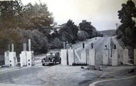
A typical Roadblock showing large concrete obstacles with RSJ uprights and Barbed Wire.
Note oil lamps for illumination after dark.
Picture most probably taken somewhere in Southern England.
From wartime publication, photographer unknown.
Note oil lamps for illumination after dark.
Picture most probably taken somewhere in Southern England.
From wartime publication, photographer unknown.

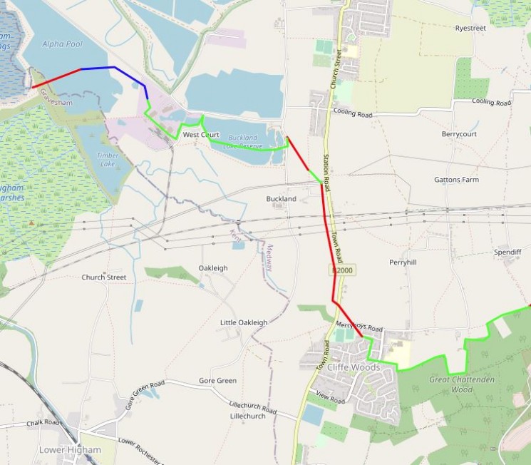
Map showing the GHQ Stop Line anti-tank ditches.

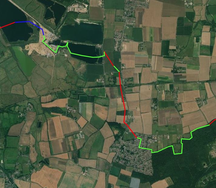
Map showing satelite imagery of the extent of the GHQ Stop line on today's environment..
MAP SHOWING ELEMENTS
ITEMISING THE ELEMENTS + PHOTOS OF: PILLBOXES, PIMPLES, DRAGON TEETH ETC
MOVING FORWARD TO PROTECTING THE STOP LINE – KCC, MEDWAY, NHP, LOCAL GROUPS
The following list of surviving features comes from the excellent Historic England report on the Hoo Peninsula GHQ Stop Line. The report can be downloaded from Historic England here.
- · Second World War Type 24 pillbox in good condition, located about 100m due south from the junction of Cooling Common and Cooling Street, Cooling, at the edge of Berry Court Wood, near the foot of a north west facing slope, overlooking an apparent gap between the wood and a section of the Stop Line's anti-tank ditch. It was recorded on 1944, 1953 and 2007 aerial photographs. It was seen to be in good condition from a public footpath during a 2014 site visit. Recorded in good condition during the Defence of Britain Project. TQ 7473 7374
- · A probable Second World War anti-tank gun emplacement or pillbox is located at the edge of Ratly Hills Wood, on the lower part of a north west facing slope near Cliffe Woods. It overlooks a gap in the stop line. The feature was recorded on aerial photographs taken between 1942 and 1961, but was no longer visible on photographs taken in 1992. Current condition unknown. TQ 7439 7354
- · A probable Second World War anti-tank gun emplacement or pillbox is located near the end of this section of the anti-tank ditch. Recorded on 1942 aerial photographs but not after 1961. This area is now the site of a school. TQ 7406 7366
- · Second World War pillbox in a hedge adjacent to the eastern end of this section of the anti-tank ditch on the northern edge of Cliffe Woods. The pillbox last appeared on aerial photographs taken in 1947. This area has been developed for housing. TQ 7403 7368
- · A rectangular structure, probably a Type 28A Second World War pillbox, or, an anti-tank gun emplacement, to the west of the anti-tank ditch. The pillbox is recorded on aerial photographs until at least 1961, but is not visible on 1992 photographs. This area has been developed for housing. TQ 7383 7373
- · A Second World War Type 24 pillbox on the northern edge of Cliffe Woods to the west of the anti-tank ditch. The pillbox was visible on aerial photographs up to 1961 but was removed before 1992. Sub-surface remains may survive. TQ 7370 7375
- · Second World War Type 24 pillbox with brick shuttering. The pillbox is a narrow wall version, facing north. The pillbox overlooked the road from Frindsbury to Cliffe and was located to the south west of the stop line. The pillbox was faintly visible on aerial photographs taken in 1944 and could be seen on photographs taken in 2003, but had been removed by 2007. It was located in garden of private house 150m east of Town Road at side of a farm road, Cliffe. TQ 73500 73275
- · Second World War concrete Type 24 pillbox located adjacent to a track at the edge of an orchard, to the west of Town Road, Cliffe Woods. The pillbox is a narrow wall version, with a brick skin. Recorded on 2007 aerial photographs (PGA) and partially on 2013 aerial photographs (Google Earth). TQ 7327 7328
- · Second World War reinforced concrete Type 24 pillbox adjacent to pond in field, on north side of Lille Church Road, facing north. Recorded on 2013 aerial photographs (Google Earth). TQ 73242 73074
- · Second World War concrete type 24 pillbox within an old hedge line, between Buckland Road and Lillechurch Road. Recorded on 1947 aerial photographs but is under tree cover on later photographs. Recorded during the Defence of Britain Project. TQ 72712 73368
- · Second World War reinforced concrete Type 24 pillbox, located within the corner of a field to the south of Gore Green Rd, Faces North-East to cover Buckland Road from Cliffe. Recorded on 1947 and 2007 aerial photographs. Observed during May 2015 field visit. TQ 72512 73252
- · A possible Second World War pillbox seen to the north-west of Buckland Road at the southern edge of the orchards of Little Oakleigh. Recorded on 1947 aerial photographs but May 2015 field visit suggests it has been removed. TQ 72541 73442
- · Second World War concrete pillbox on the western edge of Cliffe Woods. Located 360m to the south west of the anti-tank ditch and faced north along Town Road amid the bungalows of a pre-war housing estate. Recorded on aerial photographs taken between 1942 and 1961, but had been removed by housing development by 1970. TQ 7354 7357
- · Second World War Type 24 pillbox, reinforced concrete. Faces north east and is fronted by a small drainage ditch. Narrow wall version with brick skin. Recorded on 2007 aerial photographs and marked on recent OS 1:2500 scale map, at edge of orchard off footpath from B2000. TQ 73420 73738
- · Second World War reinforced concrete Type 24 pillbox with brick shuttering, near Eastcroft Farm, on the east side of Town Road, Cliffe. It is a narrow wall version with brick skin, and faces north and is located to the west of the anti-tank ditch. Recorded on 1944 and 2013 (Google Earth) aerial photographs. Appeared in good condition during a field visit in 2014. TQ 73655 73964
- · Two Second World War reinforced concrete artillery pillboxes (brick-shuttered), at right angles to each other but not apparently interconnected. 20m west of Town Road to the north of Cliffe Woods and to the west of the anti-tank ditch. Aerial photographs taken in May 1944 show the pillboxes within a military installation, with five military support buildings. The support buildings were removed by January 1947, while the two pillboxes were visible on aerial photographs until at least April 2007. Buildings were constructed on the site by September 2013 (Google Earth). A May 2015 field visit, from the public highway, confirmed that a pillbox, one of the buildings, and a row of garages seem to remain. TQ 73610 7401
- · Second World War reinforced concrete Type 24 pillbox, located at the edge of field to the west of Town Road, Cliffe, approximately 184 m to the west of the anti-tank ditch. The pillbox faces west and is a narrow wall version with a brick skin. It is situated on cultivated land at the western edge of a field. The pillbox is visible as an extant structure on recent aerial imagery (Google Earth 2013). TQ 7346 7432
- · A probable type 24 Second World War pillbox located in the southern end of the garden of The Old Rectory. This pillbox was mapped from 1946 aerial photographs. It is possible that this pillbox may be one of the two removed pillboxes described as being located within the orchard to the north of this, just behind the hedge on Rectory Road (NRHE 1418671 and 1418672). Neither of the removed pillboxes could be seen on the aerial photographs taken in 1946 when the pillbox in the south of the orchard could clearly be seen. No access was possible during a field visit in May 2015 and the pillbox could not be observed. TQ 7341 7484
- · Second World War pillbox, possibly Type 24. Visible recent aerial photographs (Google Earth 2013) TQ 7101 7573
- Four concrete blocks (each 1.2m) in a square arrangement 4.2m x 4.2m, 225m. Recorded on RAF aerial photographs taken in March 1941. Removed during post war quarrying. TQ 7125 7613
